Archaeology Post-Natural Disaster


A few weeks ago, at the end of February, areas surrounding the Red Cedar River flooded causing substantial damage to many homes, businesses, and areas of MSU. The combination of unseasonably warm weather (which melted the prior weeks heavy snow) and heavy rains resulted in the Lansing area experiencing some of its heaviest flooding in 40 years (the Red Cedar River was nearly 4 feet over flood stage). Roads were closed, states of emergency were declared, and on campus IPF worked to mitigate the flood impact to critical buildings on north campus. No structures on campus were critically damaged, but the floodwaters did leave a substantial amount of damage. At least 4 inches of additional silt along the riverbanks was deposited and unfortunately due to the contaminated nature of flood water (from drainage overflow and system purges from upriver) the debris has the potential for some biological contamination. I was out of town at a conference so when I heard about the flooding my first thought was “is my house ok?”, and the second was “what is this flood going to do to archaeological sites in the area?”.
This isn’t the first, nor will it be the last time the Red Cedar River floods. Floods and storms can add to the areas ground surface (like the silt deposition did along the Red Cedar) or can erode away river banks and cliff sides. This can expose new parts of previously known sites, uncover unknown archaeological resources (like this historic canoe that washed up after Hurricane Irma, or the skeleton found under a tree knocked over by Hurricane Ophelia), or the alluvial deposition can bury sites.


Although we thankfully haven’t had to deal with this on campus, wildfires are a common occurrence in the Western United States. Wildfires can damage archaeological sites by physically damaging the artifacts or features, or by exposing sites to the elements and erosion. Fires are also known to expose undocumented sites and expose new portions of previously recorded sites. With the increase in wildfires across the western United States, many archaeologists are finding themselves studying fire archaeology (archaeologicalconservancy.org). It’s important for archaeologists to survey areas of fire damage to record and sometimes recover artifacts before looters arrive, or animals, people, or the elements further damage the objects/site. The recovered artifacts also help to establish the boundaries of a site.
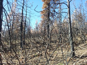
Fire also clears areas that may have previously been too densely covered by vegetation to survey. For example the American Fire in August of 2013 (located in Northern California) burned away Manzanita (an incredibly dense brush that is absolutely horrible to survey through) allowing for the documentation of the late 19th century trash scatter and gold mining prospectors pits (as seen in the photo). The fire also exposed this historic cabin (seen below and also from the 1800s), but the fire didn’t burn the foundation timbers because they were covered in a thick layer of vegetation. Additionally the fire was fast moving and cool in this area. The fire also uncovered a large trash scatter around the cabin that was previously unobservable.


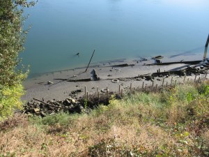
Archaeologists have also been working to document the impact of climate change on archaeological resources. Changing water levels due to drought can expose objects previously covered by water, like this ferry boat in California. The poles and brush in a row at the toe of the levee (where the vegetation ends) was where normal water flow levels hit. Conversely the rising sea levels are putting costal sites in danger of destruction. Archaeologists are racing to document and salvage these important resources, such as this commission in California. Thawing permafrost is also exposing and damaging sites caught in the melt.
Here at CAP much of our work focuses on planned campus construction, so this flood serves to remind us to always be prepared for the unexpected. Stay turned to the blog and our social media pages as we conduct a pedestrian survey of the flooded area later this month.
Author: Lisa Bright
References:
http://www.mlive.com/news/index.ssf/2018/02/msu_kayak.html
https://www.hcn.org/articles/wildfire-archeology-exposes-treasures-of-the-dead
https://www.archaeologicalconservancy.org/california-wildfires-borax-lake-archaeology/
http://www.sciencemag.org/news/2017/09/hurricane-irma-update-ravaged-barbuda-archaeology-center-tries-pick-pieces
https://www.huffingtonpost.com/entry/canoe-hurricane-irma-historical-artifact_us_59be70a6e4b02da0e1429d17
http://www.ancient-origins.net/news-history-archaeology/after-storm-hurricane-ophelia-reveals-ancient-mystery-skeleton-ireland-021675
Bagwell, Margaret 2009 After the Storm, Destruction and Reconstruction: The Potential for an Archaeology of Hurricane Katrina. Archaeologies: Journal of the World Archaeological Congress 5(1):280-292.
https://archive.archaeology.org/0903/etc/climate_change.html
https://news.nationalgeographic.com/2018/01/glacier-archaeology-norway-oppland-mountains-climate-change-melting-ice-spd/