Hi, my name is Katie Simonson and I am one of the students taking part in the 2024 field school, where we are working on the site of the original observatory here on MSU’s campus. Part of the foundations were found earlier in May of …
This academic year has allowed me to explore several digital methods I had little to no knowledge about. This is partially due to my teaching position at MSU in the Lab for the Education and Advancement in Digital Research (LEADR). While in this position, I …
This past summer has been one of the busiest, if not the busiest, summers of my time as director of the MSU Campus Archaeology Program. While we did not have a field school as we generally run them every other year, a remarkable discovery was made in May of 2023. As construction workers were installing hammock poles near Wills House, they hit a concrete platform. Thankfully, we work closely with Infrastructure, Planning, and Facilities (IPF), who oversee all construction projects on campus.
We were then contacted by Landscape Architect Yun Cao, who told us about the hammock poles and asked if we had additional information about the history of this particular area of campus. Ben Akey, our current Campus Archaeologist, examined our historic maps, historic aerial photographs, and GIS database to reconstruct the landscape’s alterations and changes over time. Ben discovered that MSU’s first observatory dating to circa 1880/1881 was close by, and then investigated the area by conducting shovel tests, or small holes in the ground designed to locate artifacts and architectural features swiftly.
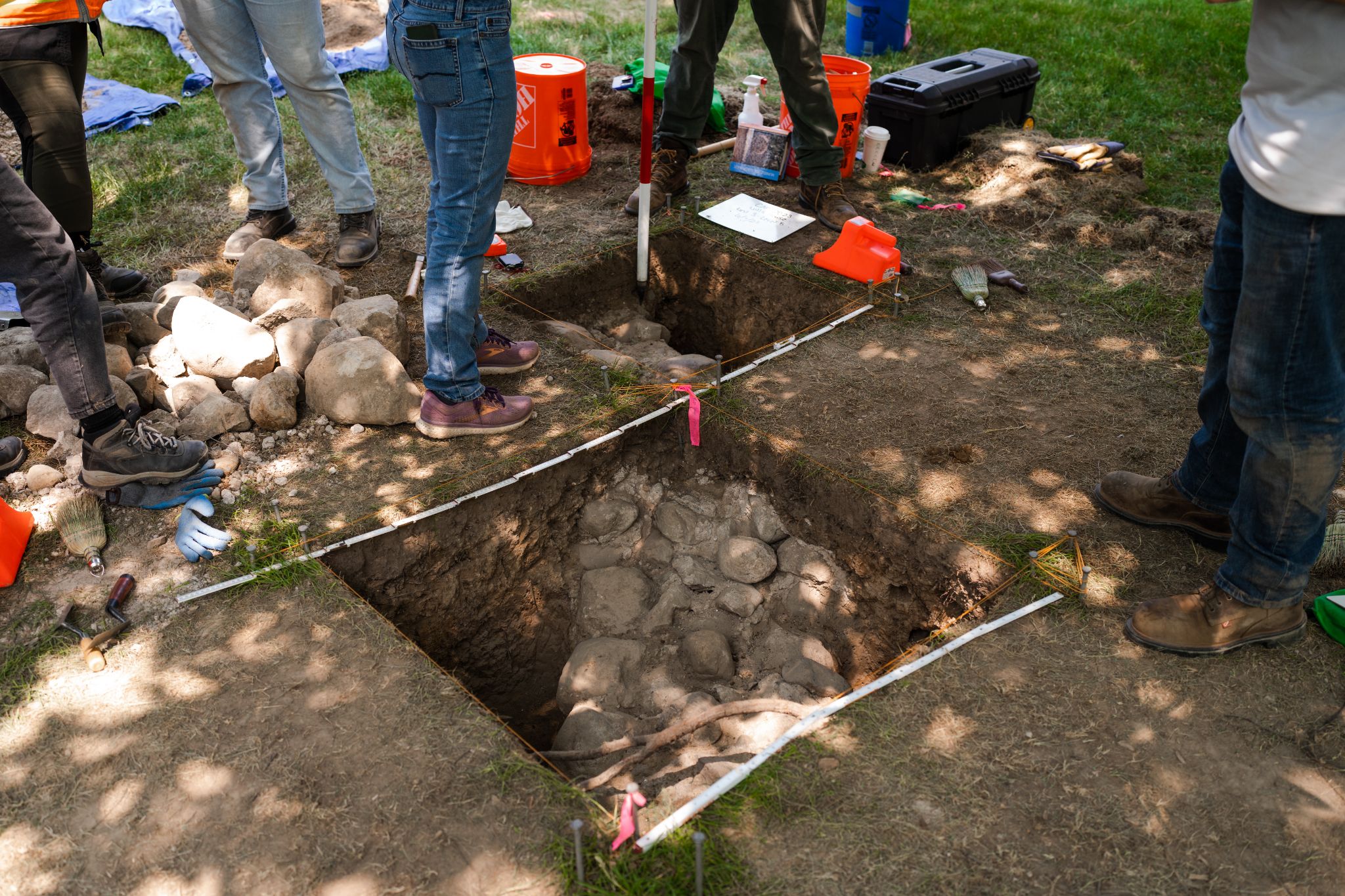
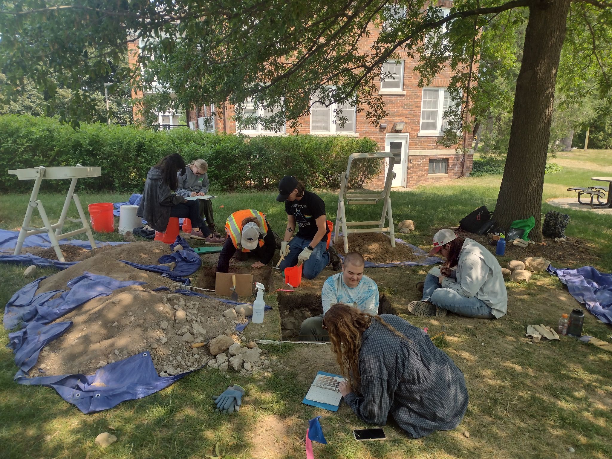
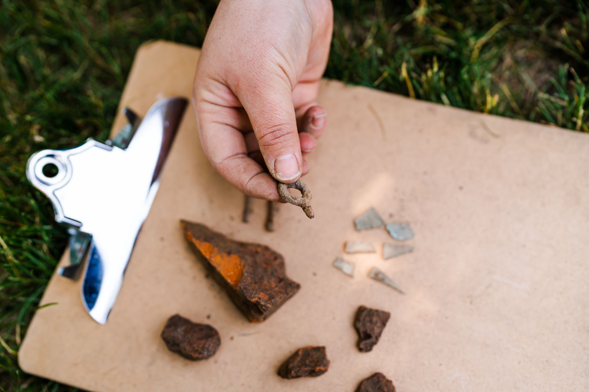
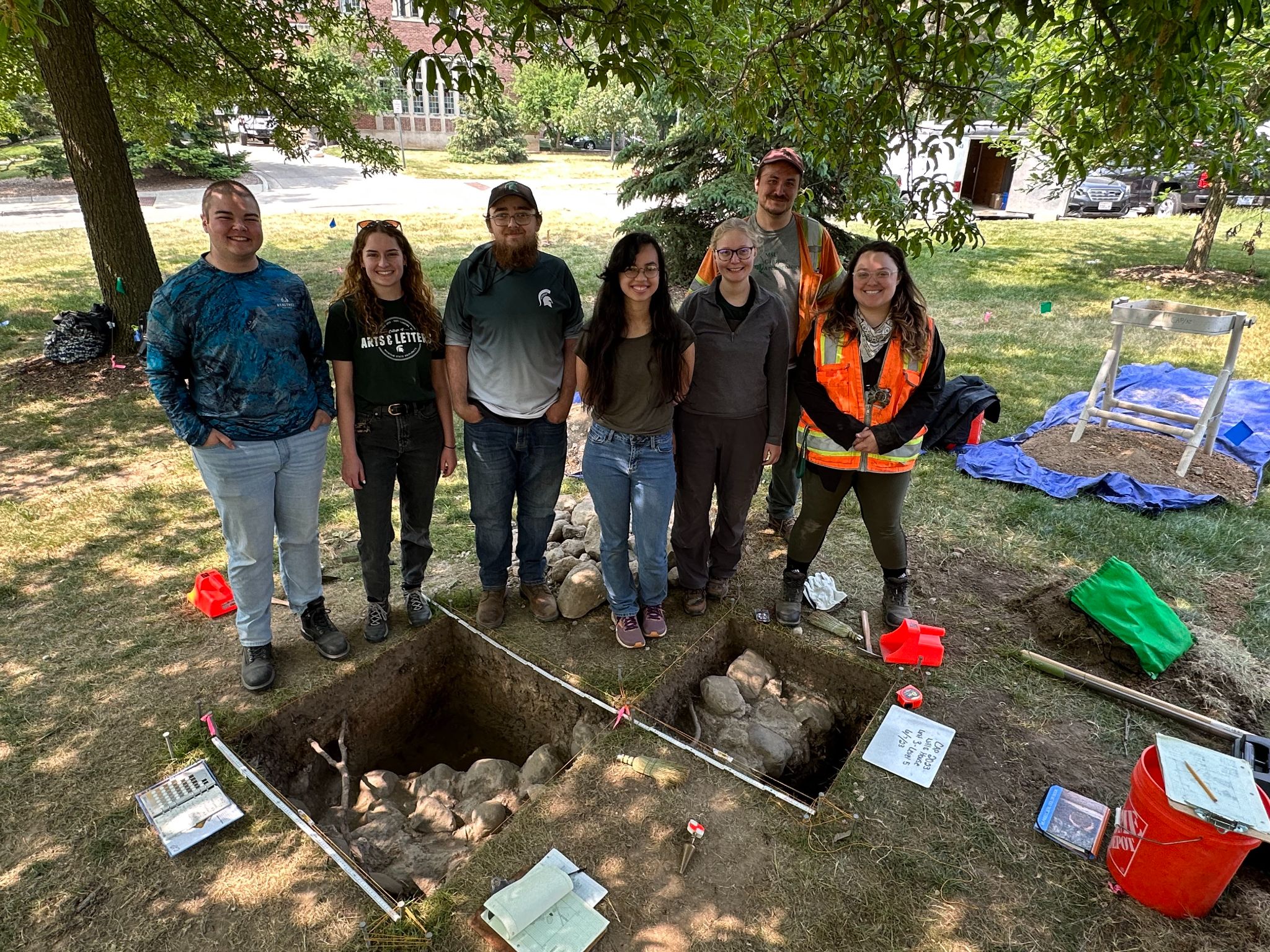
The shovel tests revealed a number of architectural-related artifacts, such as nails, glass, stones, and brick fragments. While this material culture is commonly found across our campus due to substantial construction over time, Ben had the foresight to open up 1×1 meter excavation units to further explore the structural materials. As a result, portions of the original foundation were uncovered, leading to an explosion of interest from the media and our campus community! Below you can see the two 1×1 meter units that exposed the observatory’s foundation and our team of graduate and undergraduate students excavating it.
Since we had several other critical construction projects taking place in the summer, we decided to close up the units and move to our other sites. We made this decision because we knew the site was not slated for construction and would not be destroyed over the next year. We knew that this would be a great place to study as part of an undergraduate field school, too, so we decided to carefully backfill the excavation units with dirt, using materials to protect the foundation in the process.
This summer (2024) we will be returning to the site, and undergraduate and graduate students will have the opportunity to excavate the remaining portions of the foundations. We will also have the chance to try to locate other features from this time period; perhaps we will find an outhouse that was used by the students who studied in the observatory, or Professor Rolla Carpenter himself! More information about the field school can be found on our website here.
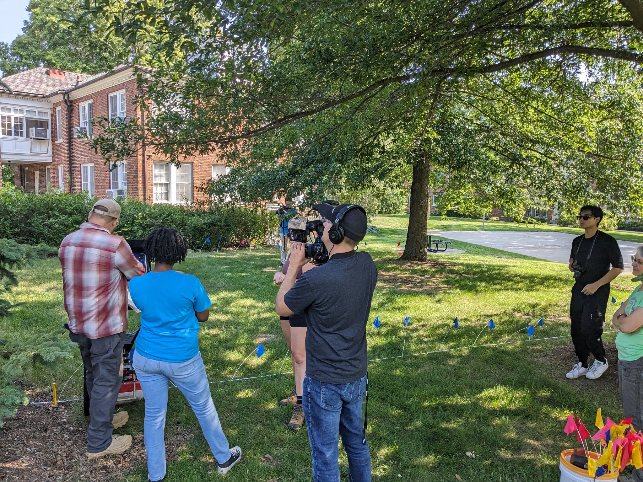
One of the questions I wanted to answer before the summer ended was if the entire circular foundation was intact. Dr. Duane Quates (an alumni of our program) and Dr. Chris Valvano (also an alumni!) kindly visited the site and conducted a ground penetrating radar survey (GPR) of it. They just so happened to be there during a day when PBS/WKAR was filming a show on archaeology and STEM with a teenage actress, who was able to get to try out GPR!
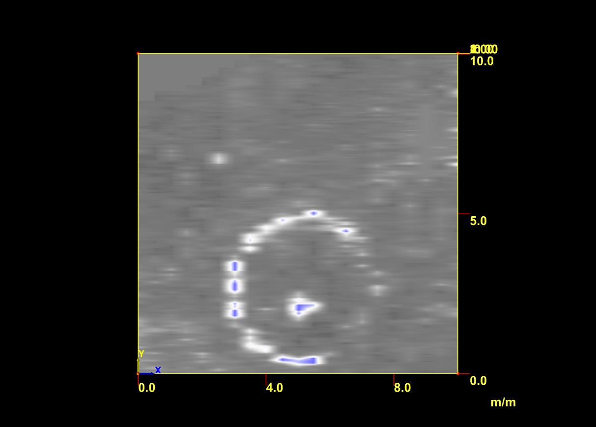
I learned a bit about what it was like to be on television, and we also learned more about what was literally hidden beneath our feet. While the GPR data is preliminary, it appears as though most of the observatory’s foundation is intact (see image of the GPR data below). We will find out more when we return to excavating in late May of 2024.
As you can tell from the GPR data, the foundation was circular, about 16 feet across. Archival records also note that the observatory was this size. There is a unique feature in the middle of the observatory’s foundation. It appears as though there may be a platform for the telescope originally housed in the observatory. This is a common for observatories, as the foundation is intentionally separate from that which stabilizes the telescope.
Since we all recognized what a remarkable discovery this was, we immediately shared our finding with communications and public relations staff at MSU. Alex Tekip, Sydney Hawkins, and Nick Schrader came out to the site immediately, taking photographs, videos, and interviewing our staff on site. I knew this was an important story, but I did not realize that this would become an international story nearly overnight! In July, we were fielding media requests daily, which was a learning experience for myself and my students. We received advice and help from Alex, which was greatly appreciated. Thanks to MSU PR’s hard work and detailed write-up of our discovery, we were featured in national and international media outlets, including People Magazine, the New York Times, the Washington Post, NPR, USA Today, the Guardian, Popular Science, and Space. Interest in the site hasn’t died down, as Smithsonian Magazine just named us one of the most 117 interesting and exciting discoveries of 2023!
To help facilitate additional research on the observatory before we hold our field school this summer, I was able to obtain a Provost’s Undergraduate Research Initiative (PURI) grant for one of my undergraduate students, Hannah. This will allow us to clean and catalog the artifacts found during last summer (see the image of some of them below), and locate additional archival documents and images related to the observatory. Believe it or not, with the help of MSU University Archives & Historical Collections Hannah has already found a previously undiscovered image of the observatory, revealing another mystery. This photo below illustrates what looks to be a small bench or structure above ground. We have talked to a number of folks about it, including MSU Professor Emeritus (of Astronomy and Astrophysics) Dr. Horace Smith, who wrote a book on the history of astronomy at MSU. There are a lot of ideas as to what this feature is – we hope to solve this mystery in the summer!
Image courtesy of Jenny Rankin and Hannah Magnus. Found by Hannah Magnus at the MSU University Archives & Historical Collections, UA 10.3.65 Charles Philip Close papers, Scrapbook #62 (dates from 1891-1895). Photo identifier A010539.
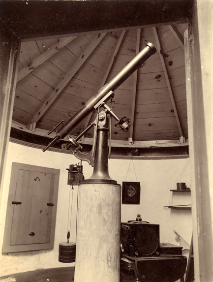
There is still a lot of work to be done at the observatory site, but we are writing up a long summary of it that will hopefully be published in the near future. The observatory was built with the assistance of student labor, a common practice in MSU’s earliest days. Professor Rolla Carpenter, pictured below, was also was able to obtain funding for the telescope inside the observatory, which now sits at MSU’s Abrams Planetarium in an exhibit. It is incredible to think that the original telescope inside the observatory is still alive and well in our planetarium!
The only known photograph of the interior of MSU’s first observatory, with telescope in the center. This telescope is currently on exhibit at MSU’s Abrams Planetarium. The podium in the center might be the circular feature identified via the GPR survey. Photo courtesy of MSU University Archives & Historical Collections. Resource identifier A000122.jpg. Photo circa 1909.
Dr. Shannon Schmoll, Director of the Abrams Planetarium, and I are working to coordinate a more robust exhibit at the Abrams Planetarium that will include artifacts and new photographs. It is a work in progress, but we hope to share more about it later this year. Shannon, her intern, Caitlyn Tanner, and I have had a couple of adventures this past year to learn more about the observatory and the people who used it. We visited Detroit Observatory in the fall, which dates to 1854 (a bit earlier than MSU’s observatory, and a lot more grand in size!), and then some of MSU Museum‘s enormous textiles collection in late fall. The textiles collection gave us a sense of what students and professors wore on campus in the 1880s and 1890s. We were curious if we might be able to see clothing similar to that which students wore in the MSU observatory photograph below.
Photo courtesy of MSU University Archives & Historical Collections, Collection Number UA 10.3.265. Photo circa 1888. Professor Rolla Carpenter, who helped obtain funding for the observatory and taught classes in astronomy at MSU, is pictured in the center of the photograph, tipping his hat.
We have so many questions about the observatory. Hannah, our PURI grant recipient, is spending hours in MSU’s University Archives & Historical Collections looking for previously undiscovered photos of the observatory (which she already discovered on day 1 of being in the archives!). She is hoping to identify some of the people in the above photograph. Who is the sole woman in the photograph? In the late 1800s, it was unusual for a woman to have access to a university education. We presume she may have been the daughter of a faculty member on campus. And what about the men? Who are they? There weren’t many students at MSU during this time period, so hopefully we can identify each and every individual photographed – if we are lucky, maybe we will even located their descendants. Maybe some of them are walking on this campus as I write 🙂
We are very thankful to the crew of MSU students who were a part of this incredible discovery. These students include (from left to right of the image below: Levi (undergraduate student), Morgan (undergraduate student), Mac (undergraduate student), Kelly (undergraduate student), Holly (Ph.D. student), Ben (Campus Archaeology, Ph.D. student), and Tori (Ph.D. student)). If it wasn’t for student labor, the observatory wouldn’t have been built. And if it wasn’t for student labor, we wouldn’t have discovered the observatory 143 years later!
Holly Long I love tea; I drink it every single day. It is warm, hydrating, and is known for healing properties. But the tea leaves most drink today are imported and are not indigenous to North America and are rarely grown here. Tea leaves, not …
Construction along Service Road in 2020 found a mid-20th-century midden. The artifacts found were associated with the history of temporary post-World War II student housing on Michigan State’s campus. After the Servicemen’s Readjustment Act of 1944, or the GI Bill, became law, college enrollment increased …
As we near the end of the semester, I want to reflect on one of my favorite experiences of fall 2022: the Midwest Historical Archaeology Conference! This year’s conference was organized by: Dr. Michael S. Nassaney, Professor Emeritus of Western Michigan University; our own Director of the Michigan State University Campus Archaeology Program, Dr. Stacey Camp; Dr. Stacy Tchorzynski, Michigan State Historic Preservation Office (SHPO) and Department Natural Resources (DNR) archaeologist; and Dr. Krysta Ryzewski, Associate Professor at Wayne State University. I attended this conference as a volunteer, but had the opportunity to sit and listen to many researchers speak about their ongoing research in the midwest.
Dr. Nassaney gave the introduction and explained that the theme of the 2022 program was Archaeology, Communities, and Civil Rights. He further explained historical archaeology is relevant to the present, especially regarding civil rights issues. The following talks and posters reiterated the importance of historical archaeology in conversations about civil rights.
The first half of the day included two podium presentations from Dr. Ryzewski and Floyd Mansberger. Dr. Ryzewski’s presentation focused on their work in Inkster, Michigan, and was titled “Updates from the Field: The Archaeology of Malcolm X.” The house excavated is where Malcolm X converted to Islam, where ritual bathing and daily prayers were practiced. The house was originally going to be demolished, but due to the work of Aaron Sims, the house is now undergoing a four-phase process that has seen the house added to the National Register of Historic Places in 2022, archaeological investigations that have seen a lot of community engagement, and in the future will involve restoration and the creation of a community center.
Floyd Mansberger, Director of Fever River Research, presented “The Archaeology of the 1908 Springfield Riot.” There were five houses that were found in an area that was not under protection, so Mansberger and his team conducted an archaeological mitigation on these houses. Many artifacts were found, including some burnt items. Some of the artifacts found suggested that a family of color may have been living in one of the houses. Some of these artifacts include items from the Eighth Illinois Regiment, the first all Black and POC regiment. There were also Civil War artifacts associated with the households.
During lunch, Julia DiLaura, a student from Wayne State University, presented her poster titled “Taking the Plunge: Archaeology of a 20th Century Jewish-Owned Bath House and Mikveh in Detroit.” She showcased the artifacts found at the site.
After the poster presentation, two additional speakers presented their research and updates. First was Dr. Laura Ng, Assistant Professor at Grinnell College. In her talk, “Towards Community-Engaged Chinese Diaspora Archaeologies in the Midwest,” she discussed the history of how people and goods moved, along with the issues and racism that contemporary Asian-American communities face. While Dr. Ng has previously worked on the west coast and in China, she shared how transnational and anti-racist frameworks should be used more in midwestern settings and how to implement those frameworks. Some archaeological literature reinforces biased language and stereotypes, and archaeologists need to step in and work toward changing this language and stereotyping. In addition, she spoke on her community-engaged work with findagrave.com, where people can find the location of graves of passed friends and loved ones.
The last podium presentation of the day was given by Sarah Surface-Evans, Senior Archaeologist for SHPO. Her presentation was titled “Asinii-Waakaa’igan (Stone House): The Cornerstone of Sanctuary and Community.” She and her team have been working with the Pelcher family to learn more about how the Pelcher family farmstead played a role in the lives of children who ran away from the Mount Pleasant Indian Industrial Boarding School (MIIBS). Two Peltcher family members perished at MIIBS, leaving the family as one of many who lost their children to the school. Oral history has indicated that the farmstead was a safe haven for children, where hand-me-down clothes were left for children to change into. A joint field school with students from Central Michigan University (CMU) and Saginaw Chippewa Tribal College (SCTC) was held, where units were dug in the areas where the old granary, barn, and cabin once stood. Many different types of artifacts were found, along with faunal remains. An analysis of the faunal remains was conducted, and they found that there were many cattle bones present. Following all of the talks, a break-out discussion was held about participants’ interests.
Needless to say, MHAC presented an incredible learning experience for those present. As a non-midwesterner myself, I really enjoyed having the opportunity to learn more about the ongoing archaeological work in the region.
While cataloguing artifacts from Service Road, we stumbled across an intriguing piece of a milk glass jar featuring an applied color label with bright red and blue hues. I say it was intriguing because many of the artifacts we have left from Service Road are …
This past summer, the Campus Archaeology program had the opportunity to offer a field school to archaeology students from MSU and across the state—our first field school since the beginning of the Covid-19 pandemic. Directly taking part in ongoing CAP research into life in the …
I wanted this blog to be about patents, not Ruth Van Tellingen. Or should I call her Ruth Bendel? Or Ruth Elizabeth Thompson? I’m getting ahead of myself. Before we delve into Ruth’s life, let’s review the concept of patents as they pertain to archaeology.
As many know, a patent refers to a legally-recognized title on intellectual property that allows an individual or group to control the production and sale of specific designs. In the U.S. patents, as a legal concept, extend back to the late 1600s when some individual states would grant legal rights to an idea or invention. Federal interventions on designs and innovations were not introduced until The Patent Act of 1790. The registration number associated with a granted patent is often printed on items that become artifacts. These numbers provide a multi-tool for archaeological interpretations. With them, we can often identify a purpose or maker of an artifact and a period for the use and production of an item. Sometimes, patents allow us to discover unexpected insights into our social pasts.
The CAP Patent that Gave Paws
About a year ago, I was sitting in the CAP lab researching a ceramic bear. The item was uncovered during our 2020 Service Road Construction Project (read more here). We had plans to use the artifact in a conference presentation covering Children’s lives on MSU’s campus (read more here).
Ceramic bear condiment dispenser. Use your mouse to rotate the object. Shaker holes are visible on the back of the head. Ruth Van Tellingen is visible in writing on the base.
When searching the patent for the bear I found that it is not merely a decorative item, but rather a clever and original design for two interlocking condiment dispensers (salt, pepper, oil, etc.) (read more here). Something else caught my attention– something other than the unconventional nickname, “Huggers”. It was the title associated with the patent, filed on May 6th, 1947… The name belonged to… a woman?
Ruth Van Tellingen Bendel’s 1951 “Huggers” patent.
Ruth Van Tellingen Bendel. Let me be clear. I was not surprised a woman had invented a new design or kindled an original concept. My eyebrows were raised because the idea was documented and credited to her. Archeologists, like anyone looking into the past, generally struggle to find and verify diversity in the past, especially when it comes to historically marginalized or oppressed groups. Without identifiers like patents, it can be difficult, if not impossible, to identify who created something. Objects themselves do not have social identities– humans assign them. And because restricted and privileged groups have historically held the pen that writes the Western narrative, many historical accounts overestimate the contributions of certain individuals to society. In the same stroke, the experiences of people outside of the most privileged circles have been silenced or ignored (1).
Woman with a Peppered Past
So what can we know about the creator of this patent? Ruth Elizabeth Thompson was born in Hinsdale, Illinois, in 1910. Census records tell us she married Oscar Van Tellingen, a salesman from Iowa, and assumed the role of a “Housewife and commercial artist” by the age of 30 (see census data below).
1930 census form. Oscar H.M. and Ruth E. Van Tellingen shared their home with Clyde N. Hale, an electrical technician from Nebraska.
Ruth’s occupation on the 1930 census. We know that this line was filled out by her husband, Oscar, because of the star next to his name in the previous image. In addition to claiming a more traditional role of housewife, she was also identified as a commercial artist.
Her artistry, including several children’s books, received mixed reviews (2). While active in illustration, she also commissioned figurines created for the Chicago Royal China and Novelty Company (3), including the multiple Huggers in different animal forms. Her interlocking bear design was conceived in 1947, but not submitted for a patent until 1949. Our bear lacks the name “Bendel,” which Ruth added after her second marriage to Victor T. Bendel, in 1948. It is therefore likely one of the first bears off the production line.
Ruth’s shaker patent, granted in 1951, preceded the women’s liberation movement (4) in the United States by more than a decade. Women first patented a product in the U.S. in 1809, but as of 2020, the percentage of self-identified women contributing to annual patents remains less than 22% (5; 6). By the time she died in 1986, Ruth had acquired at least two more patents, several copyrights, and was listed as an author on multiple books. Between two CAP fellows, we found seven names associated with Ruth’s life. Even by today’s standards, her intellectual capital and enigmatic flair for unique titles would be considered remarkable.
Time to Shake It Up
Want to explore patents yourself? Here are two possible methods:
To search patents through the U.S. government portal navigate to:
The landing page should provide a patent number and issue date. To view the scanned file, click “Images” at the bottom. Have in mind that most patents are a few pages long, so you’ll want to download more than the landing page of the PDF. It is also worthwhile to note that some patents may have a number in front of them, which indicates the type of patent represented.
Google now offers a patent look-up that’s even easier:
Type in the name or number and anything affiliated with an individual should show. Between patents and copyrights, we found the following names associated with our Ruth to stamp her intellectual and artistic endeavors. Give ‘er a go and see what you find.
Ruth Elizabeth Thompson.
Ruth E. Van Tellingen.
Ruth Thompson Van Tellingen.
Ruth Van Tellingen Bendel.
Ruth V. Bendel.
Ruth Bendel.
Ruth Thompson Bendel.
References
Trouillot, Michel-Rolph (1995) Silencing the Past: Power and the Production of History. Beacon Press, Boston, Massachusetts. Link
Greetings! For those of you just joining our blog for the first time, I am Dr. Camp, the Director of the MSU Campus Archaeology Program (CAP). I am entering my 5th year here at MSU, and my 13th teaching as a tenure track faculty member …


